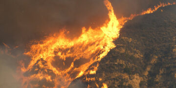


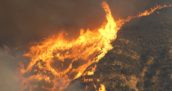
LOS ANGELES, CA – The wildfires that swept through Los Angeles County this year have left thousands of homes in ruins, particularly in areas where neighborhoods meet undeveloped land—what fire officials and researchers call the wildland-urban interface, or WUI. This zone, where human development blends with natural landscapes, has been at the center of some of California’s most devastating fires, including the recent Palisades and Eaton fires.
With 2025 already ranking as the second most destructive fire year in state history, more than 16,000 homes and structures have been damaged or destroyed. Most of them were in the WUI, a sprawling 7-million-acre zone where nearly 14 million Californians—one in three state residents—live. According to the U.S. Fire Administration, the WUI is expanding by about 2 million acres per year nationwide, raising concerns about fire risk as more homes are built in fire-prone areas.
When a wildfire moves into the WUI, the transition from burning vegetation to igniting homes can be swift and devastating. California has built extensively in these areas for decades, with nearly 45% of new homes constructed between 1990 and 2020 located in places with high wildfire potential. While not every WUI neighborhood is guaranteed to burn, thousands of homes have been lost over the past decade as fires increasingly impact populated areas.
The Toll of Wildfires in the WUI
The Eaton Fire, which tore through the San Gabriel Valley, killed at least 17 people and destroyed more than 9,400 structures, roughly 9,200 of which were in the WUI. Altadena, a community at the base of the San Gabriel Mountains, suffered extensive damage as fire conditions overwhelmed firefighting efforts.
The Palisades Fire, another major wildfire in Los Angeles County this year, raced down the Santa Monica Mountains toward the Pacific Palisades neighborhood. Fueled by hurricane-force winds, it destroyed at least 6,800 structures, while nearly 4,100 remained intact. Pacific Palisades, a densely developed coastal community, is almost entirely within the WUI, highlighting the challenges of protecting homes in fire-prone regions.
Historically, California’s most devastating wildfires have disproportionately affected WUI communities. The 2018 Camp Fire, the deadliest wildfire in state history, destroyed nearly 20,000 structures and killed 85 people in Butte County. The fire burned through both the natural environment and the town of Paradise, demonstrating how quickly flames can spread when homes are in close proximity to wildland vegetation.
However, not every home in the WUI is equally vulnerable. The likelihood of destruction depends on several factors, including building materials, defensible space, and weather conditions at the time of the fire. In some cases, homes remain untouched while neighboring structures are reduced to ash, illustrating the role of both preparation and chance.
Beyond the WUI: Rethinking Fire Risk
While the WUI is a critical factor in assessing wildfire danger, some experts caution against using it as the sole measure of risk. The 2017 Tubbs Fire in Sonoma County, for example, leveled the Coffey Park neighborhood in Santa Rosa, which was not technically within the WUI but sat adjacent to it. The fire, driven by extreme winds, jumped highways and ignited urban neighborhoods, underscoring the complexity of wildfire behavior.
Sarah McCaffrey, a former U.S. Forest Service social scientist, explains that wildfires and structural fires increasingly overlap. “Structural fires and wildland fires—the interface is where the two come together,” she said. While the WUI designation helps define where urban development meets undeveloped land, it does not inherently indicate fire risk.
Judson Boomhower, an assistant professor of economics at UC San Diego, argues that focusing solely on the WUI may overlook other critical factors. “There’s actually a legal or technical forestry definition of the wildland-urban interface, and it has to do with the number of structures per acre and the amount of vegetation,” he said. “I think sometimes it’s more useful to talk about building in high wildfire hazard places.”
Strategies for Reducing Fire Risk
Reducing the risk of wildfire destruction in the WUI depends on various factors, including how closely homes are built together. In neighborhoods where houses are spaced at least 80 to 100 feet apart, defensible space measures—such as clearing flammable vegetation and creating buffer zones—can improve a home’s chances of survival.
However, in densely packed communities like Pacific Palisades, fire prevention strategies become more complicated. Even homes built with ember-resistant materials may be vulnerable if flames spread from one structure to another. In 2021, California Governor Gavin Newsom signed a law requiring state fire officials to recommend new measures for reducing ember exposure within five feet of buildings in high-risk fire zones.
State policies have played a role in improving fire resilience. Research from 2021 found that homes built in California after 2008 were nearly half as likely to be destroyed in a wildfire compared to those built in 1990, largely due to updated building codes. These regulations include requirements for fire-resistant roofing, tempered glass windows, and enclosed eaves that prevent embers from entering a structure.
The Future of Development in Fire-Prone Areas
California continues to grapple with a chronic housing shortage while facing more intense wildfires fueled by climate change. With millions of residents already living in the WUI, policymakers must balance the need for housing with wildfire preparedness. The growing threat of megafires raises questions about where homes should be rebuilt after disasters and how communities can be better protected.
Despite recent policy efforts, fires continue to devastate WUI neighborhoods, forcing officials to consider long-term strategies for fire adaptation. As wildfires become more frequent and severe, the intersection of development and fire risk will remain a critical issue for California’s future.
